SEFS-led research points to wildlife cameras as a potential source for improving snow cover maps

New research led by SEFS Ph.D. Candidate Catherine (Katie) Breen highlights remote cameras deployed to monitor wildlife as an untapped source of snow cover observations. Published in the journal Remote Sensing of Environment last week, Breen and her advisor, Associate Professor Laura Prugh, worked with colleagues at the Norwegian Institute for Nature Research and NASA on a method combining international datasets to validate and improve satellite observations of snow cover using imagery from wildlife camera networks.

lynx running in snow
The wildlife camera network is optimized for lynx detection, but is also a useful tool for snow mapping. Image courtesy of Norwegian Institute for Nature Research. For more information, please visit: viltkamera.nina.no

Globally, snow cover observations are used for hydrological forecasting, predicting the timing of snow melt and seasonal snow patterns, water resource planning, and animal migration patterns. Currently, satellite observations provide daily data on snow cover, but cloud and forest cover among other factors can impede the accuracy of the information.

To address this limitation and improve snow cover observations, Breen and Prugh sought to combine their respective backgrounds in remote sensing and wildlife science to explore how existing networks of wildlife cameras could supplement satellite observations to produce a more accurate picture of snow cover patterns. Colleagues in Norway working with expansive wildlife camera dataset presented an opportunity to pursue the novel concept.

“Dr. Prugh’s experience ensured expert use of camera trap datasets, and I helped bring experience with satellite datasets. Our collaborators at NASA are leaders in remote sensing for snow. The final missing piece was an extensive camera trap dataset from a highly respected Norwegian research team,” said Breen.

Breen received a NASA Graduate Fellowship and a Fellowship from the American Scandinavian Foundation and traveled to Norway to work with the Norwegian Institute for Nature Research (NINA). NINA, an applied ecological research center, hosts a network of camera traps across the country to track wildlife populations and biodiversity.

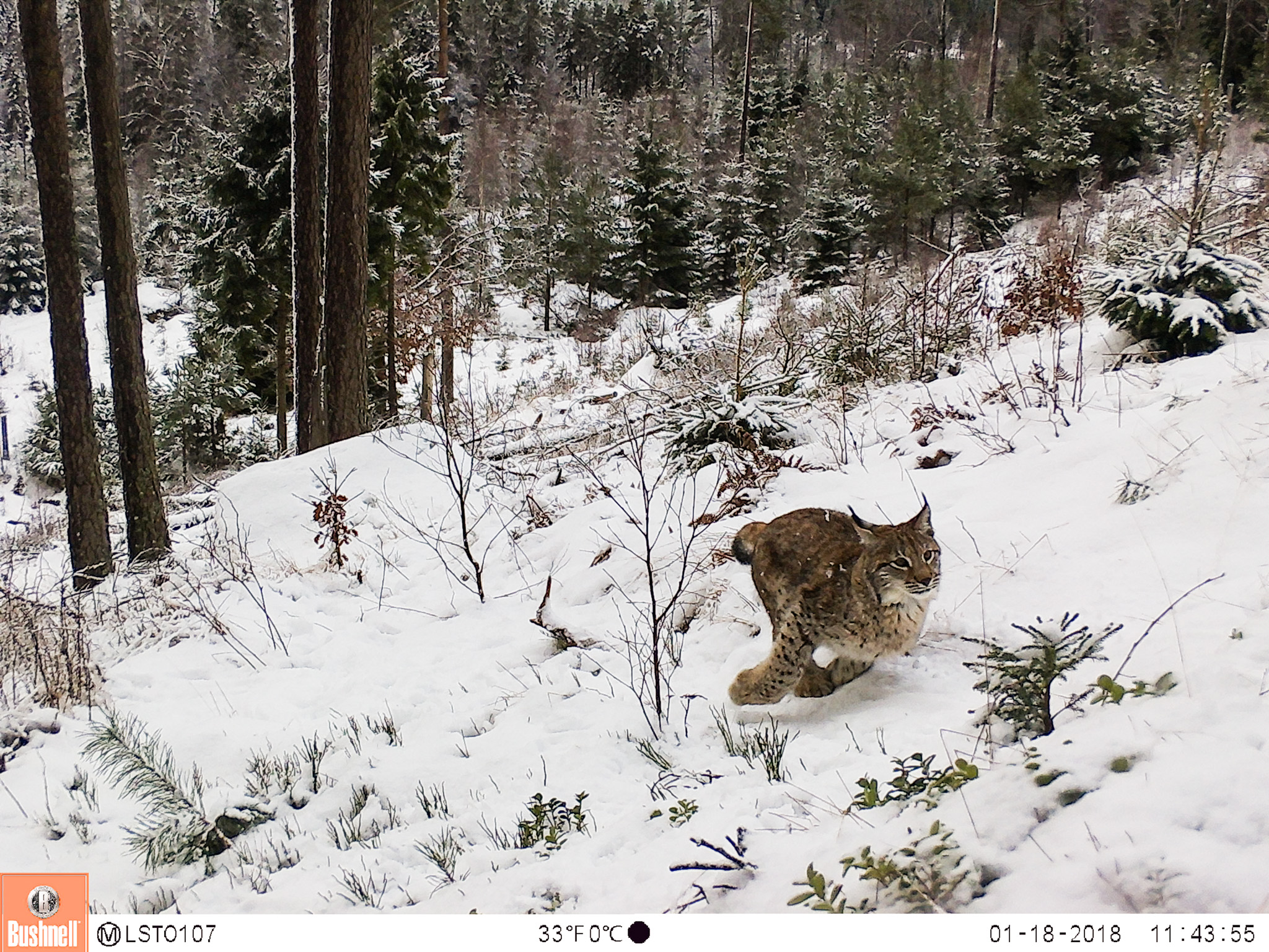
The researchers used data from over one thousand wildlife cameras, spread across 10 degrees of latitude through the forested, mountainous, and coastal regions of Norway. Along with information on wildlife habits and movement, each camera provides a trove of observations about on-the-ground snow conditions throughout the year.

Whether the observations would align with satellite imagery given the differences in scale was uncertain. While the wildlife cameras capture a field of view of about 20 to 30 meters, satellite observations are made at a scale of 500 meters, or the size of several football fields. To their surprise, the team found strong agreement between the camera trap data and satellite observations on the presence or absence of snow across the region.

“In some ways, the cameras are even more accurate because they allow you to see below the tree crowns and get some of the on-the-ground information that satellites don’t have access to,” said Breen.

However, the datasets diverge after several days of consistent cloud cover. Satellites measure snow cover based on the reflectivity of the ground surface, and in the presence of clouds, the last clear-day observation is used to predict what current conditions may be. After three or four cloudy days, the predicted value could stray significantly from true conditions on the ground as snow or rainfall may have rapidly increased or decreased the total area under snow.

Positioned beneath the cloud cover and vegetation that could hinder satellite observations, wildlife cameras provide an avenue to pinpoint sources of inaccuracies in the imagery. This research highlights the potential of remote camera networks to supplement satellite observations and create more reliable snow cover maps, particularly in regions that see heavy cloud cover throughout the winter, such as Norway and the Pacific Northwest.

As the wildlife ecology community continues to expand camera networks to monitor biodiversity, a growing opportunity exists to enhance our understanding of changing snow conditions with ground-based remote sensing data on a global scale. In a changing climate, there is an urgent need for information on the rapidly changing water availability and wildlife patterns.

The unexpected opportunity to collaborate with an ecological institute across the globe has made this research possible, said Breen. Her time with the Norwegian Institute for Nature Research allowed her to immerse herself in a new culture while completing her PhD, and even explore her own Scandinavian heritage.

“It’s exciting to draw together datasets from different research teams, different technologies, and even different fields of science, and still find they can build on one another,” said Breen.


SEFS Involved in Four Major NASA Grants

As part of its Terrestrial Ecology Program, NASA recently launched the Arctic-Boreal Vulnerability Experiment (ABoVE). It’s a major field campaign in Alaska and western Canada—starting this year, and lasting 8 to 10 years—with the goal of better understanding the vulnerability and resilience of ecosystems and society to a changing climate in Arctic and boreal regions. In 2015, NASA awarded grants to 21 projects as part this campaign, and four of the proposals involve researchers at the School of Environmental and Forest Sciences (SEFS)!

A Dall sheep ram.
Dall sheep ram.

New faculty member Laura Prugh had two proposals funded, including one as the principal investigator (PI) and another as a co-PI. The first, “Assessing alpine ecosystem vulnerability to environmental change using Dall sheep as an iconic indicator species,” will involve synthesis and modeling of Dall sheep population and movement data throughout their range, developing new remote sensing layers of snow characteristics, and conducting fieldwork in Wrangell-St. Elias National Park. The research will be funded for $1 million over four years.

The second project, “Animals on the move: Remotely based determination of key drivers influencing movements and habitat selection of highly mobile fauna throughout the ABoVE study domain,” will synthesize and model movements of moose, caribou, wolves and grizzly bears throughout Alaska and western Canada. Prugh’s role in this research will be to model the wolf and bear movements, and there is a $200,000 sub-award in the grant for her to hire a postdoc for two years to lead that work.

Professor David Butman is a co-PI on a third proposal, “Vulnerability of inland waters and the aquatic carbon cycle to changing permafrost and climate across boreal northwestern North America,” that focuses on changes to carbon biogeochemistry in lakes as a result of thawing permafrost. Specifically, the project aims to evaluate potential impacts in boreal and Arctic regions as permafrost thaw, climate warming and fire change the “plumbing” that controls water movement and distribution. The total award for this proposal is around $2.1 million, with $1.2 million coming from NASA and the other $900,000 coming from the U.S. Geological Survey. Of that total amount, around $110,000 will come to SEFS from NASA to fund a student for two years, and $30,000 will come from the USGS for summer support for Professor Butman.

The fourth SEFS project involves co-PI Hans-Erik Andersen, a research forester with the U.S. Forest Service Pacific Northwest Research Station and an affiliate professor with SEFS. This proposal, “Fingerprinting Three Decades of Changes in Interior Alaska (1982-2014) Using Field Measurements, Stereo Air Photos, and G-LiHT Data,” will explore changes in vegetation cover and composition over time to characterize the vulnerability and likely future trajectories of these landscapes under projected warming and scenarios of future disturbances. The project is funded at $334,564 over three years.

To have nearly 20 percent of the funded proposals in 2015 involve SEFS is a fairly remarkable percentage, and we’re excited to see how these projects progress!

Photo by © Steve Arthur.


Notes from the Field: Helicopter Sampling in Alaska

Earlier this week, Professor David Butman returned from spending 11 days in the Yukon Flats National Wildlife Refuge in Alaska, where he had the memorable opportunity to conduct his field sampling by helicopter and float plane. He was able to coordinate the trip on a shoestring budget, as well, thanks to a great partnership with NASA and colleagues at the University of North Carolina, the U.S. Geological Survey, and Civil & Environmental Engineering at the University of Washington (where Butman holds a joint appointment).

Yukon Flats National Wildlife Refuge.

Professor Butman’s research involves measuring fluxes of carbon dioxide and methane in water systems—especially in Arctic and boreal ecosystems—and how those releases of greenhouse gasses are impacting the global carbon cycle and climate change. At a conference two years ago, he connected with Professor Tamlin Pavelsky, a hydrologist at the University of North Carolina’s Department of Geological Sciences. They stayed in touch and kept talking about potential collaborations, and their interests eventually aligned over an engineering project in Alaska.

Pavelsky has been helping with field calibration for a new radar sensor that NASA’s Jet Propulsion Laboratory is planning to launch on a satellite in 2020. Through its Surface Water and Ocean Topography, or SWOT, mission, NASA is developing this sensor to observe changes in water level to within a millimeter of accuracy, which will have important applications for measuring water volume in lakes and rivers, as well as impacts of flooding.

Daylight extended until nearly midnight, giving them incredibly long days to collect samples. “You lose track of time,” says Butman, taking a “sampling selfie” here.
Daylight extended until nearly midnight, giving them incredibly long days to collect samples. “You lose track of time,” says Butman (taking a “sampling selfie” here).

Right now, they’re in the middle of an intense campaign to calibrate the radar sensor and test it by flying over different landforms and water features. So when Butman learned from Pavelsky that some of those test sites would include the Yukon Flats, he pitched the idea of tagging along to conduct his own biogeochemistry measurements at the same time. He had already marked some of those same areas for future sampling, and the timing was perfect to draw different programs together for common goals. NASA agreed to bring him along, and they ended up covering the expense of the helicopter and plane flights in Alaska, and Butman handled the equipment and labor.

He seized the opportunity and spent 16 to 17 hours in the field on the trip. Butman flew around with a pilot and a student technician to assist him, locating lakes from the air and heading down to take measurements. Assisted by Alaska’s endless summer sunshine, they were able to collect tons of data from 18 different lakes. “It was kind of exciting,” he says. “Some of these systems have never been measured.”

Butman has another proposal in with NASA to fund continued research in the Yukon area, and he definitely hopes to get back up there next year. “It was one of my top three field experiences so far, for sure.”

Photos © David Butman.

2015_06_Butman3